Some questions that get asked often about precision ag, and precision tools in general, are “what makes sense for my operation?” or “how do I get started?
The best way to answer these questions is by evaluating your current situation. How you respond to the following questions should guide you toward your next logical ‘precision ag steps’.
- Do you have spatial soil samples (grid or zone) on any of your fields (<4 years old)?
Are you making variable rate fertilizer applications based on these samples? - Does your combine, or your custom harvester’s combine, have a GPS equipped yield monitor?
- Is your planter equipped or capable of variable rate seeding?
- How are you evaluating or verifying your current production?
- How are you evaluating or verifying the efficacy of your precision ag tools?
- How are you evaluating the economic return of your farm? Individual fields?
“across your entire operation? Agronomically, and economically?
I consider a good spatial soil sample the foundation of precision ag. By definition, precision ag is all about site-specific management; measuring, analyzing, and managing field variability. As mentioned in our previous blog post, Buyer’s Remorse, states the definition of precision is; the quality, condition, or fact of being exact and accurate. What better way to start that with a spatial sample?
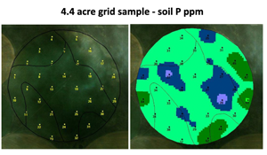
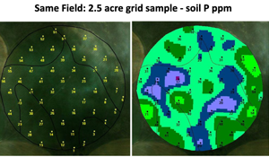
Two predominant methods prevail in the spatial soil sample world; grid sampling and zone sampling. In my experience, I consider the 2.5 acre grid sample the best ‘right-size & high resolution image’ of soil fertility you can collect. While other grid densities and zone approaches work in different geographies (and can meet your needs in different growing environments…dryland Kansas or dryland Saskatchewan wheat come to mind), the 2.5 acre grid sample offers what I consider the best match of agronomics and economics. It typically provides the “Goldilocks” scenario of high sample resolution, enabling you to see what’s going on within the field, while being cost effective for the grower.


Your number one priority with any spatial soil sample is to measure the variability of soil fertility within a field. Regardless of how uniform a field may appear (table-top flat, same soil type, negligible topography change), universally, soil fertility is variable, ceteris paribus. More importantly, through your years of farming that ground and perhaps yield monitoring, you know yield is also variable. By measuring and understanding this variability, you can begin formulating successful variable rate fertility plans (VRT).
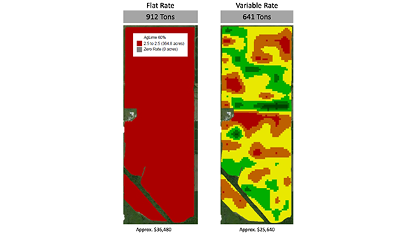
Spatial soil sampling and VRT, in and of themselves, may not save you money at the outset. However, they will make you more efficient in the long run by reallocating the fertilizer dollar where it needs to go within the field. In almost every flat-rate situation – we over-apply our poor areas and under-apply our best areas. This leads to input waste in the poor areas, and uncaptured yield potential in the best areas. By adopting a sound VRT approach, and working with a trusted agronomic advisor, we can optimize both our fertilizer spend and our overall yield potential.

In future articles, we’ll discuss the benefits of variable rate seeding, determining the right seeding rate, yield data, Management Zones, and whole-season systems based approaches, that incorporate all aspects of VRT, VR seeding, in-field trials, and comprehensive yield, agronomic, and economic analyses.
