Share Your Farm Data?

It’s hard to avoid hearing about the promise of “big data.” Thanks to Edward Snowden’s proposition, we need your non- partnership to use your data to revelations, it is also easy to spin conspiracy theories. There are many big-data analytics examples cited, such as Amazon and Netflix. They suggest books and movies we may enjoy based on what we have “liked” in the past or what other people who seem similar to us like. Google, the National Security Agency and others evidently collect data about what we search, what and whom we email, and much more.

There seem to be several “values” from big-data analytics. Many companies’ goals are to monetize data through better value propositions to their customers, like selling advertising, how they position products, differential pricing, etc. Another goal is to reliably predict behavior. For example, Bob shares a common background and behavior as Tim, and Tim likes this brand; therefore, Bob must like it, as well.

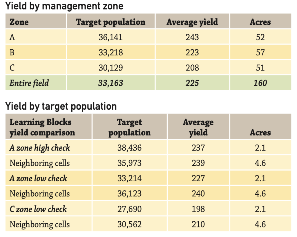
Reliably predicting behavior, better product value propositions and differential pricing are all examples of how companies could use your agronomic data. For example, your field’s soils are X, Y, Z, and hybrids A, B, C outperformed hybrids Q, R, S on 85% of the X, Y, Z soils; therefore, A, B, C is the best value proposition for you. The fact that your soils are X, Y, Z is “public knowledge” — because the soils data- base is public.

But a company might say, “to really perfect our value proposition, we need your non-public agronomic data. Why don’t you send us your historic yield data, your fertility data, your management information, etc.”

What can it hurt? After all, they only want to help you. The reality is, we all share “our” data with other companies, either intentionally in exchange for a benefit or inadvertently because we wanted a cool “app,” and sometimes the trade-offs are worth it.

For me, the difference between consumer data sharing and sharing your georeferenced agronomic data is profound. Your reading choices might influence what advertising you see; your agronomic data is your “business” data. There is nothing anonymous about GPS data.

Anyone with a tractor guidance system has heard about different levels of GPS accuracy. Any of those accuracies are more than sufficient to provide site-specific data about your fields when you use a documentation system.

For Premier Crop, building a partnership to use your data to make better agronomic decisions has always begun with this foundation: The grower owns the data, data is only pooled with permission, and even pooled data belongs to and is for the benefit of the growers who shared data. But Premier Crop’s history and operating principles don’t mean that’s the right way or the only way to use data to benefit growers.

Sharing your data with seed, crop protection, nutrient or machinery suppliers can make business sense. These companies sell you products that are important to your business and profitability. Sharing your data to help them provide better recommendations may well be worth any trade-off. Most important is to think through those trade-offs and each “partnership proposal.”

Got data?

  1. What are the partners going to do with the data? Perhaps more importantly — what will they assure you (in writing) they will not do?

  2. Some of your partners may be fearful of missing out on the “next big thing” if they provide the wrong answers to your questions. What questions are you asking?


Originally published in Corn and Soybean Digest.

Success in VR Seeding

I try very hard not to fall in the trap of “geek” talk. It’s a special challenge, as we have a company full of geeks! Even though we hire a lot of “normal” people, within a year we typically convert them into farming geeks/ nerds. They still look normal, but they aren’t. I describe what we do as the collision of agronomy and technology. It’s the technology side that leads us to become geeks.

One word I’ve tried to avoid overusing is “spatial” — rhymes with racial — defined as relating to space and the relation- ship of objects within it. Precision ag tools allow us to map spatial differences within a field; yields and fertility are common examples. For many, maps have been a powerful way to visualize the spatial variability that exists in most fields. For some, these maps confirm what we’ve always known to exist — significant differences within fields.

For almost a decade, Premier Crop and our customers have experienced terrific success in creating value for growers with variable-rate seeding prescriptions. Our process is simple. Create management zones by identifying the best part of the field, where you want to be more aggressive (A zones). C zones or other lower letter zones are usually used for the lower-yielding area, where being more conservative with seeding rates might be warranted. B zones end up with the “average” part of the field — neither great nor limited.


Now, with millions of acres successfully and profitably variable-rate seeded, one observation worth sharing is that it is very rare for a management zone to run in a straight line from one end of a field to the other. This management zone map is the rule, not the exception.
In our company’s early years, we did plenty of strip trial approaches where treatments and checks ran across the
entire field. But we came to understand that most strip trials are running treatments across tremendous spatial variability, which is frequently ignored in the analysis. Averaging the results for treatment strips and ignoring the effect of spatial differences tends to mask what is really happening. Gains in the A zones can be “averaged” down by the results from C and D zones.

For many, analyzing variable-rate planting with strip trials
has resulted in conclusions that aren’t positive for the practice. Our results and experiences have been the opposite. Using higher and lower Learning Blocks within management zones and analyzing yield results have led to even faster adoption.

Got data?

  1. Off the top of your head, what types of variability do you think lie across a field?
  2. For what kinds of treatment would it make sense to run trials across an entire field?


Originally published in Corn and Soybean Digest.

Mind the Gap

If you’ve ever traveled to London and been a passenger on their subway system, the “tube,” you’ve heard the phrase “mind the gap.” It’s kind of funny because that’s not how Americans would say it. We’d probably say “watch your step.” The long, straight cars and the curves in the tracks cause gaps between the train cars and the loading platform; therefore, passengers are warned to “mind the gap.”

This phrase is relevant to all of us who are trying to create value from data. The gap we need to mind is the gap in time that exists between when the field is harvested and when results can be delivered to the grower. Historically, the gap exists for several reasons. Many growers tend to be focused on the task at hand in the fall — the physical work of getting the crop harvested, lime and nutrients applied, and in some cases, tillage operations. Downloading yield cards is something they can do later; the same goes for the decisions they will make from the data. Harvest season priorities and decisions tend to focus on where to take a bumper crop when the “wet bin” is full and the line at the elevator is backed up.

Technology offers an answer to close the gap, and the wireless transfer of data can eliminate the gap, but there is a catch — data quality.

I get challenged on data quality all the time. Frequently, when I present at a large conference, there are skeptics and “unbelievers” in the audience. Usually, someone will make a comment about “all the bad yield data out there.” My response is to defend growers. If I’m a grower and I’ve never made a decision using my yield data, after a few years I will likely quit caring about calibration. But Premier Crop’s experience is that when growers understand how they can use their data to make better decisions, they drive everyone involved crazy in getting their data perfect! If their grain cart scales say the field average is 236.7 bushels per acre and the yield file says 229.7 bushels per acre, they expect us to correct the yield file. So while it might be true that many farmers haven’t taken the time in the past to calibrate their yield monitor, there is a logical reason for their lack of attention.

Telematics — being able to send data wirelessly — offers advantages to all of us in agriculture. But in many cases, it can mean we have sped up how fast we move inaccurate data. And you know the saying: “garbage in, garbage out.”

At Premier Crop, our customers are in the thick of delivering 2014 data analysis results to growers. For our customers and staff that means a lot of “fixing” data. But data fixing doesn’t stop at the yield file. Why would data need to be fixed? Many times, it’s because something didn’t get logged correctly or as completely as needed.

Many companies are now offering data analysis solutions that rely heavily on telematics as their service’s backbone. I saw an example recently where the company was providing an independent benchmarking for genetic performance by soils driven by their telematics solution.
The problem is many times not all the data needed to provide quality analysis is logged. Five different growers might have logged that they were planting Channel 207-13. But that hybrid has five different trait combinations ranging from conventional to SmartStax (see table for examples). Averaging the yield for all five trait combinations into one number isn’t an accurate comparison.

Quality data analysis relies on quality data. And quality data requires hard work and attention to detail. Even though we can use technology to make the timing gap smaller, we all must still “mind the data quality gap.”


Originally published in Corn and Soybean Digest.